Taos to
Santa Fe
The High Road through New Mexico — 90 miles of adobe villages, sacred canyons, and art culture that has drawn travelers for centuries. The American Southwest at its most distilled.
The drive between Taos and Santa Fe offers two entirely different New Mexicos. Take the Low Road along the Rio Grande for speed and drama. Take the High Road through Truchas and Chimayó for the soul of the place — 17th-century Spanish mission churches, weaving studios, and mountain villages that look unchanged from a century ago.
For Prevost owners, the High Road requires careful planning. The village centers are narrow and the switchbacks above Truchas demand slow speeds. But the payoff — Chimayó's sacred chapel, the views from Truchas Peak, the art galleries of Tesuque — make it worth every careful mile. The Rio Grande Gorge Bridge alone is worth the detour from wherever you are.
Route Map
Hover any marker for details — Rick's Picks, coach notes, fuel stops, and campgrounds.

Must-Stop Destinations
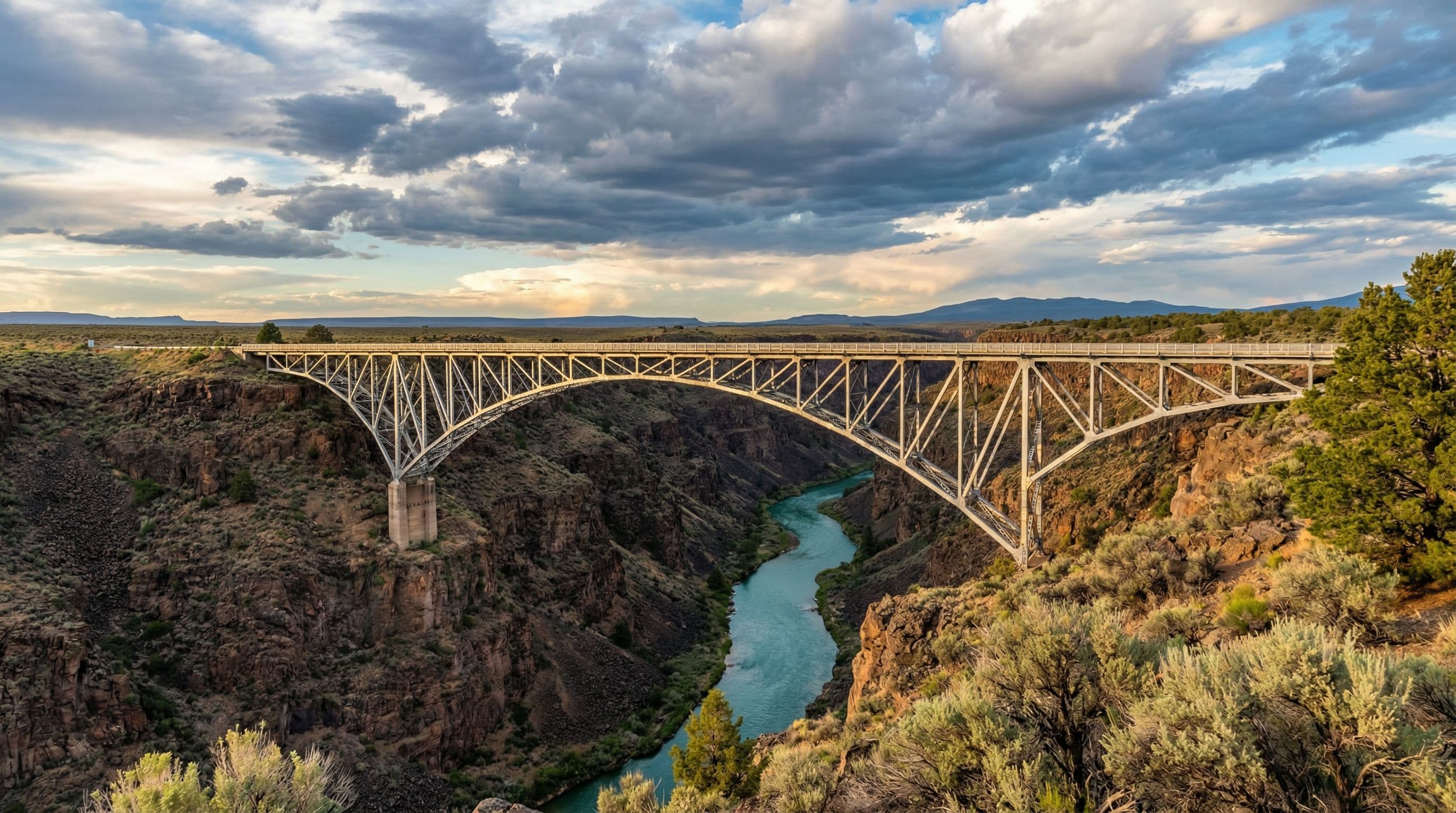
Rio Grande Gorge Bridge
One of the most dramatic one-minute experiences in the American Southwest. The highway is flat desert in every direction — then the earth splits open 650 feet beneath you. Pull off in the large lot on the west side. Walk to the center of the bridge and look straight down at the Rio Grande threading through its ancient volcanic canyon. Few people are ever prepared for the scale.
Park the coach in the large BLM lot on the west approach. The bridge itself is accessible on foot only. Sunset turns the basalt walls amber-red — worth timing your departure from Taos accordingly.

Santuario de Chimayó
The most-visited pilgrimage site in the United States. The 1816 adobe chapel sits in a narrow valley between Taos and Santa Fe, surrounded by cottonwood trees and roadside folk art galleries. The parking situation is surprisingly manageable for large coaches — a gravel lot handles up to 45-foot rigs. The soil here is believed to be sacred. Thousands walk to it on Good Friday.
Park in the main gravel lot off CR-98. Do not attempt the narrow village streets in the coach. The walk from the lot to the Santuario is about 400 feet on a packed dirt path.
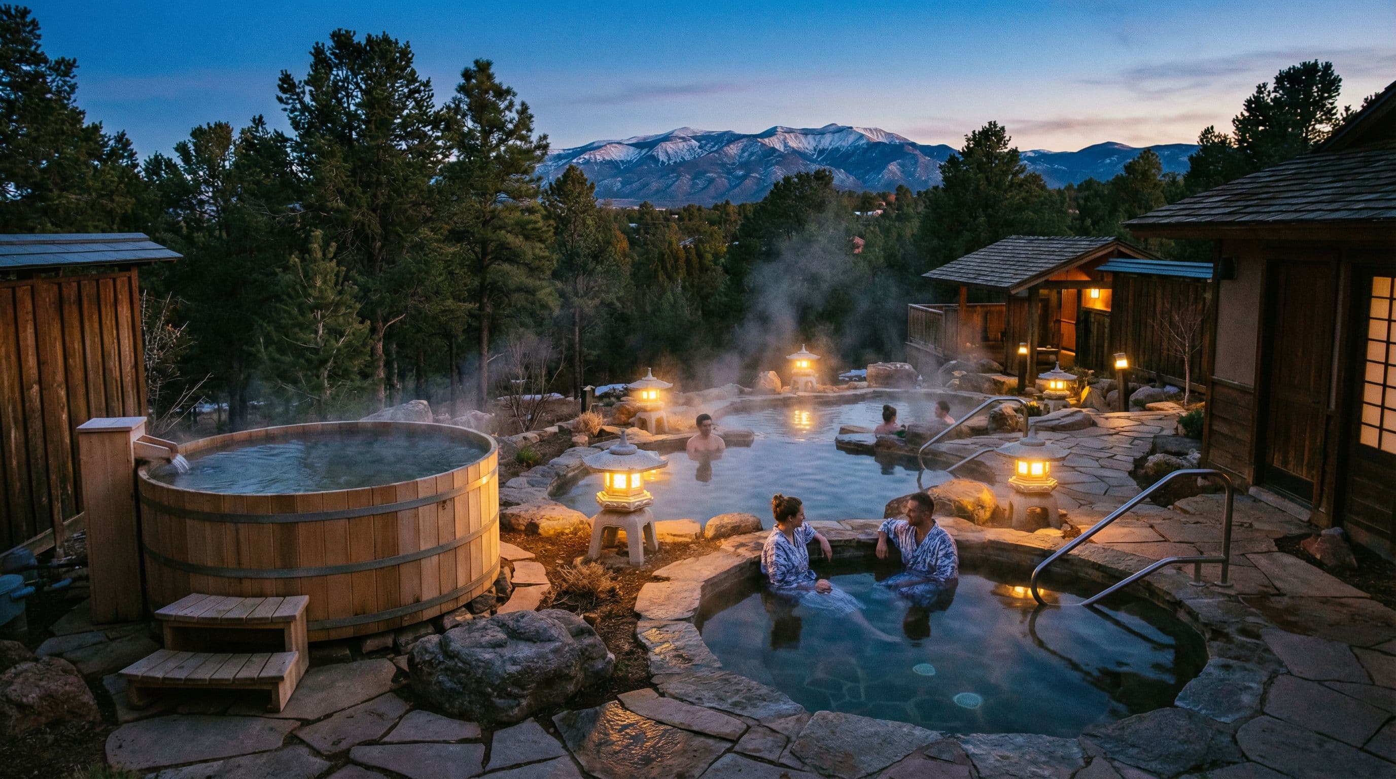
Ten Thousand Waves
A Japanese mountain spa carved into the pinon forest above Santa Fe. Hot tubs, cold plunges, salt scrubs, and private suites on a hillside that feels entirely removed from New Mexico — or anywhere, really. It is the kind of place that Prevost owners build itineraries around. Reserve private suites months ahead; public pools can be booked 2–4 weeks out.
The road to Ten Thousand Waves (Hyde Park Rd / NM-475) is windy but handles 40-foot coaches. Park in the lower lot and take the short shuttle or walk uphill. Do not attempt to turn the coach in the upper lot.
The Enchanted Circle
Enchanted Circle Scenic Byway · 84 miles · Red River, NM
Park the coach in Taos and unload the bikes. The Enchanted Circle Byway is an 84-mile loop that Road Hogs has been running for years — northeast out of Taos through Arroyo Seco, up past Taos Ski Valley, over the high desert toward Eagle Nest Lake, through the old mining town of Red River, and back down through Questa. Peak aspen color in late September. Zero traffic lights for the first 60 miles.
The Enchanted Forest trail network near Red River adds a full off-road day for members with dual-sport bikes — 25 miles of maintained forest roads through Carson National Forest at elevations between 9,000 and 11,000 feet. The trailhead at 492 Enchanted Forest Road handles small trailers if you want to haul the dirt bikes separately.
Park coach at Rancheros de Santa Fe KOA or Camel Rock — both 15 min from the byway start
Full Enchanted Circle loop. Add 25 miles for Enchanted Forest off-road network.
Aspen color peaks mid-October. Summer runs (June–August) also excellent — wildflowers at altitude.
Road Hogs has run the Enchanted Circle as a group ride every fall since 2014. Led by Rick on the High Desert Run.
Coach Road Notes
The High Road through Truchas and Las Trampas is the scenic choice but has tight switchbacks and narrow passages through village centers. Coaches over 35 feet should take the Low Road (NM-68) along the Rio Grande instead.
Low Road alternative: NM-68 south along the Rio Grande — faster, easier, still beautiful. Miss Chimayó on this route — detour via NM-76 east from Española instead.
The narrow streets surrounding the historic Santa Fe Plaza are not navigable in a 45-foot coach. Use the Rancheros de Santa Fe KOA or Camel Rock Casino as your base and drive/ride into the Plaza.
Camel Rock Casino (US-285 north) has free overnight RV parking for casino guests. Easy 15-minute Lyft or Uber to the Plaza.
The road to Ski Santa Fe and Ten Thousand Waves is winding but paved and wide enough for 40-foot coaches. Hairpin turns increase above 8,500 feet — slow to 15 mph through the tightest bends.
Do not attempt in ice or snow. Road closes during winter storm events.

“Ninety miles, two worlds — the canyon and the mountain, the ancient and the modern.”
Fuel Stops
Places to Stop
Camel Rock Casino RV Park
US-285 North of Santa Fe, NM
Rancheros de Santa Fe KOA
736 Old Las Vegas Hwy, Santa Fe, NM
Taos Valley RV Park
120 EST Valle ES, Taos, NM
Known Hazards
High Altitude — 7,000 ft+
BE AWAREThe entire route runs above 6,500 feet, with sections over 8,000. Diesel performance is reduced at altitude. Allow extra following distance — braking distances increase.
Entire route
Afternoon Monsoon Thunderstorms
USE CAUTIONJuly–September monsoon season brings intense afternoon thunderstorms that can reduce visibility to near zero within minutes. Pull off and wait them out — they typically last 20–40 minutes.
Peak season July–September
Chimayó Village Center
USE CAUTIONNarrow streets immediately around the Santuario. Park in the main lot and do not follow GPS routing through the village core — these roads are impassable for coaches.
Chimayó village, NM-76
Pro Tips
High Desert Run
2026
September 18 – 21 · Taos, NM · El Monte Sagrado base
Road Hogs takes on the High Road to Santa Fe in autumn — peak aspen color, cool high-desert evenings, and zero crowds. Based at Taos, the group runs the High Road to Chimayó on day two and rolls into Santa Fe via Canyon Road for a gallery dinner on day three. The most scenic 90 miles in the southwest.